Free Map Tools
An online resource that enables visitors to easily and quickly use maps in order to measure, search and overlay mark-up elements on maps for a wide range of useful applications. Click on one of the Map Tools below to find out more...
Popular Tools
A list of some of the map tools that are currently available for use. There is a more comprehensive list of tools and resources here.
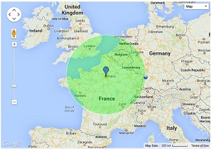
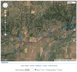
| Radius Around Point | Measure Distance |
| See the radius around a point you click on a map | Find the distance between two points that you click |
 |
 |
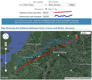
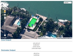
| How Far is it Between | Area Calculator |
| Find the distance between named points A and B | Calculate the enclosed area that you specify on a map |
 |
 |
Country Specific
To see a list of tools specific to a country, use one of the links below:
 |
 |
 |
 |
| Australia | Belgium | Canada | France |
 |
 |
 |
 |
| Germany | India | UK | USA |
General Tools
General map tools that are relevant to all locations.
- Area Calculator Using Maps - Find an enclosed area using a polyline on a map
- Create and Plot Encoded Polyline on Map - Plot an encoded polyline on map and draw a polyline to produce an encoded polyline
- Direction Projection Tool - Use the Direction Projection tool to visualise a projected path on a map
- Draw Concentric Circles - Draw Concentric Circles on a map
- Elevation Finder - Find an estimate for the elevation of a point on the earth
- Find Cities and Towns Inside an Area - Find cities and towns within a user drawn area
- Find Cities and Towns Inside Radius - Find cities and towns within a particular radius of a central location
- Find Line of Equidistance Between Two Points - See the path where the distance between two points is the same
- Find Place With Name - Search for a town, city or place with your name
- Find Places Within Radius - Search for places inside a radius of an address
- Find Population on Map - Define an area on a map then find out the estimated population inside
- Find Sunrise and Sunset Time at a Location - Find out the next sunrise and sunset time of any point on the earth.
- Golf Shot Distance Calculator - Record and measure the various strokes required to complete a hole of golf on a map
- Horizon Finder - Find where the visible horizon is from a point on earth using a map
- How Far Can I Travel - Find out how far you could travel by road in a set time
- How Far Does Santa Have To Travel - Find out how far it is between the North Pole and your house
- How Far Is It Between - Find the distance between two named points on the earth
- International Meeting Centre of Gravity Tool - Find the best place to hold a meeting for it's attendees by inputting various international addresse
- KML File Creator - The KML (Keyhole Markup Language) File Creator will allow you to produce KML files using a simple in
- Map Tunnelling Tool - Tunnel to the other side of the earth on a map
- Measure Distance From Central Point To Many - Find out the distance from one point to many other points
- Measure Distance on a Map - Take a measurement between two points on a map to find the distance
- Plot Airport Routes - Plot airline route networks or airport destination maps
- Radius Around a Point on a Map - Find where a radius of specified distance falls around a point on a map
- Range Finder Tool on a Map - Find out the end point location when you specify a start point, a bearing and a distance on a map
- Save Route on Map - Save a route on a map
- Time Zone Converter - Convert a time in one location to the time in another location
- Trip Calculator - Calculate the time and distance for a trip on a map
- Tunnel to the Other Side of the Google Earth - Find out what is on the other side of Google Earth
- View and Edit Photo GPS Data - Use a map to view and edit GPS data in a photo
Free Map Tools makes use of the Leaflet Maps, PHP and Ajax. This site is always being developed and improved, so check back often to see what has been updated.
Comments For This Page
Vel, this can be done on other tools on the website. For example : Find Cities and Towns Inside Radius.
By Free Map Tools on 15th April 2025
Would be helpful if it would create a list of city names and postal codes within the radius once set. Maybe downloadable to excel or something.
By Vel on 11th April 2025
Would be helpful if it would create a list of city names and postal codes within the radius once set. Maybe downloadable to excel or something.
On 2nd April 2025
page not loading and not letting me upload radius
On 19th March 2025
if you add a 10,000km radius around mexico city and tokyo, the circle centred on tokyo reaches mexico city but the circle centred on mexico city does not reach tokyo.
On 12th December 2024
Thank You
By Tony Hughes on 30th November 2024
And probably an CSV input option for colouring the pin as well? Would be great!
On 27th November 2024
Could you please add radii colouring to the CSV input options?
By Thijs Nugteren on 27th November 2024
Does this postal code list contain all postal codes for any specific area? Like is this a master list or will there be any postal codes missing? What is the source for the postal codes freemaptools supplies?
By Andrew on 26th November 2024
Thanks for the tool.
It is also possible to add the center of the radius to kml.
+ it would be nice to export drawn radii to CSV (center coordinates, radius)
By Niki on 20th November 2024
How do i find the population within the radius that i have drawn?
On 28th October 2024
Allan, Bug has been identified and fixed.
By Free Map Tools on 25th October 2024
Hi,
Thank you for making such a great tool available for use! I love it!
But there's a little bug.
I was using the CSV import to plot some circles, but selecting the "No fill" option somehow produces circles with solid fills in the same color as the "line".
Fix please. :)
By Allan.Centuple.100x[at]gmail.c on 24th October 2024
The Clear Map button should do that
By Free Map Tools on 14th October 2024
how should one loose/clear one of the blue pegs??
By Peter on 14th October 2024
Allow to import a geojson file to add overlays of counties to map
On 8th July 2024
Please add a scale to the map
On 1st May 2024
Works as intended
By Adeeb on 25th April 2024
Super useful, thank you so much!
By Hazel on 5th April 2024
nico, it is possible to add multiple and have them overlay.
By Free Map Tools on 7th March 2024
Showing the most recent 20 out of 2125 comments. Click to see all the comments.
Add your own comment below and let others know what you think:
Comments
Your Name (optional)
